[Freeciv-Dev] Re: (PR#7287) Extended Topologies
|
Complete.Org:
Mailing Lists:
Archives:
freeciv-dev:
February 2004: [Freeciv-Dev] Re: (PR#7287) Extended Topologies |
|
[Freeciv-Dev] Re: (PR#7287) Extended Topologies[Date Prev][Date Next][Thread Prev][Thread Next][Date Index] [Thread Index]
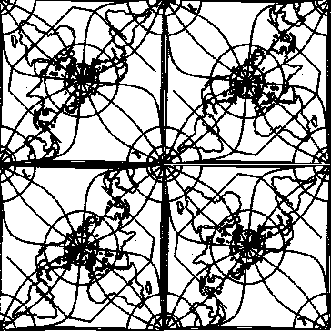
<URL: http://rt.freeciv.org/Ticket/Display.html?id=7287 >


Jason Short wrote:
> <URL: http://rt.freeciv.org/Ticket/Display.html?id=7287 >
>
> Marcelo Burda wrote:
>
>>>Consider also that the extended topologies come in several forms.  For
>>>instance an offset-wrap as I describe it above will probably not take
>>>much work to implement, but gives only a small advantage over the
>>>current torus wrapping.  A quincuncial wrapping will take a fair amount
>>>of work to implement.  It is of high theoretical interest (how many
>>>hours have we spent discussing approximations of a sphere?) but its
>>>playability hasn't been determined.  People need to _play_ this thing
>>>before we can assess it.
>>
>>the last quincuntial is realy playable topo. i need correct some
>>reversed-canvas isues and a litle extention of overview. it is not so
>>easy as a torus or a mobius(twisted torus) but kep moderatly easy after
>>some games. And it is the best aproximation of a sphere!
>
>
> I played your Earth scenario with it.  I never saw the singularities.
> But the map was so large (with so much ocean) it was basically like an
> unwrapped map.  Damn the Pacific is big!
>
> jason

Here is an attempt to present a comprehensive view of the qunincuntial
map rather than trying to figure out from small GUI windows just what
all the relationships are. One can pan a virtual GUI window over the
projection to see what things are really like. There is a little bit
of analysis below that shows Marcelo has some work cut out to make a
case, or needs to come up with some fixes to resolve the problems.


The attachment is a four-fold quincuncial map that can be simply tiled
in both cartesian axes since all complex wrappings are now folded in.

One advantage of laying out such a map is that it includes all the
complex edge joins leaving one with a simple 2-D map over which a
GUI window can float to give the picture seen by a player of the
game. Because all tiling is simple, it corresponds to the smallest
torus world which can be constructed as an alternate implementation.
Note simple tiling is what torus-worlds are effectively designed for.


The normal set for a quincunx consists of one of the four corner sets
or a square with corners at each north pole. Note that because of the
cutting and stretching of the southern hemisphere in the normal set,
and reversed join between any two normal sets, normal sets are distinct
and not representable as a square with arbitrary origin as is the
simple case when the normal set completely overlaps the torus world
and normalization involves only simple wrapping.

There are two classes of normal sets, one with each pole at the
centre and the other pole quartered in the corners. Each class
consists of non-overlapping super-tiles related by translation and
possibly rotation. The relationship between two sets in different
classes involves an extra translation component based on quartile
number.

Picking the normal set which completely or best contains the locations
in a given GUI window, and translating between map coordinates and this
set *is* a significantly complex process especially with smaller windows
where there may be more than one, i.e. one from each class.


An observation that is immediately obvious is that, while distances
may be stretched, movement between any two points within a normal set
centered on either pole is relatively sane and intuitive. On the
otherhand, when crossing from one normal set to any other within the
same class things become a little weird.

For example, one can leave the north pole heading across Asia and the
Indian Ocean ... and end up at India and eventually the North pole.
As interestingly, one can leave New Guinea heading NNW ... and in a
few tiles arrive at New Guinea. Crossing the Pacific Ocean from North
America takes you to South America.

Because most of the oddities in the quincuntial folding are confined
to the southern seas, and in fact there is a 20 degree rotation from
Grenwich meridan added to avoid clippiing S. America and making the
distortions obvious, one only sees the real effect when one looks at
land-land relationships across such oceans. Thus while it makes a very
compelling map projection in a single normal set, tiling quincunxes
introduces *very* odd results.

More importantly, if one were to drop a GUI window sized to hold both
endpoints, then you would see yourself leaving both source and
destination, running through your mirror image and arriving. Besides
the fact that this violates the rule that one can not show elements of
the normal set multiple times, the effect is clearly more than a minor
distortion of distance - it plays havoc with intuitive adjacency
relationships, and will have a tremendous negative impact on game play
map distance calculations and other core functions.


There are a number of issues arising here from how to tile normal sets
to avoid non-intuitive game effects through how to map tiles to standard
rectangular GUI windows in a way that preserves intuitive 2-D mapviews.
When you look at the broader picture, and start to see how non-simple
edge sewing can make things decideedly non-intuitive, then it is clear
that one wants to investigate just what such effects are, which sewing
ops cause which ones, and how one needs to adjust GUI displays to make
such anomalies recognizable at a minimum.

Anything less will only hurt game play rather than provide innovative
maps that enhance 2-D representations of valid gaming worlds.

Cheers,
RossW
=====
|