[Freeciv-Dev] Re: (PR#7287) Extended Topologies
|
Complete.Org:
Mailing Lists:
Archives:
freeciv-dev:
February 2004: [Freeciv-Dev] Re: (PR#7287) Extended Topologies |
|
[Freeciv-Dev] Re: (PR#7287) Extended Topologies[Date Prev][Date Next][Thread Prev][Thread Next][Date Index] [Thread Index]
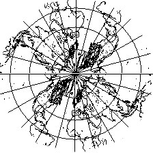
<URL: http://rt.freeciv.org/Ticket/Display.html?id=7287 >

Le mar 24/02/2004 à 04:15, Jason Short a écrit :
> <URL: http://rt.freeciv.org/Ticket/Display.html?id=7287 >
>
> Morgan Jones wrote:
> > <URL: http://rt.freeciv.org/Ticket/Display.html?id=7287 >
> >
> > I haven't really been following the discussion too closely and I don't
> > really comprehend the maths and coding involved, but the quincuncial
> > topology does sound interesting (I can't test it though).
> >
> > Looking at Ross' diagram I can see how there would be large
> > distortions in the southern hemisphere and I guess from the fact that
> > I live in the Southern hemisphere I'm not entirely happy about that
> > :)  (Besides, Antartica would be a much more interesting place to
> > fight over than the Arctic).
>
> I'm pretty sure the distortions are along the equator, not at either
> pole.  In fact they're only at certain locations on the equator,
> specifically the singularity points.  (In the center of the sides of the
> square, far out in the ocean.)
Yes.
>
> > Anyway, what I'm wondering (at the risk of making everything far too
> > complicated) is why not have two seperate maps for each hemisphere?
> > There would be a 1:1 join along the seam at the equator and from a 2d
> > GUI POV this would look seemless if the code was up to it.
>
> That is exactly what is being done here.  There are two rectangular
> pieces of cloth being sewn together along the edges.  The north pole is
> in the center of the top piece of cloth, and the south pole is in the
> center of the southern piece.
>
> Now there are two ways we can unroll this cloth.  We can take one of the
> sides and cut it up into four triangles:
>    ______
>   |\    /|
>   | \  / |
>   |  \/  |
>   |  /\  |
>   | /  \ |
>   |/____\|
>
> then unfold along the original seams to form another square twice as
> large (in area) as the original one.  This is what Marcelo's map does.
> The north pole is in the middle of one piece of cloth, and the south
> pole is in the middle of the piece that gets cut up.
>
Yes
> The other way to unroll the cloth is to cut apart 3 of the seams we
> sewed together earlier, and unfold it to be a rectangle twice as wide as
> the original square.  See
> http://rt.freeciv.org/Ticket/Attachment/39952/27550/world_rec_A.xpm for
> an example of how this could be done.  (I suspect this method will give
> a more playable map.)
Frist time a was thinck tath but realy this is more difficutl to
undestand were are the singularities.
>
> This isn't the whole story, though.  The distortion doesn't happen
> *entirely* in the folding, it happens when the projection is done.  In
> Ross's image the extra lines drawn show how the projection is done.  See
> how the circles around the arctic and antarctic are not distorted, but
> the line of the equator forms a near-square.  (I don't fully understand
> this projection; it seems imbalanced.  Why isn't the equator an exact
> square?  Marcelo, can you explain?)
Is a litle difficult for me,  i no speak good english.
Whe making the Pierce-quincuntial projection we need make something with
the curvature of the Earth. this curvature can't disapear the we
concentrate it in some point. at this points a right line is turned 90°
as eqator.
Far of this spetial point we have a Flat projection.
Near of this spestial point we have a conical projection.

If we choice to place not at ocean but at pole 2 of 4 singularities we
can see somethin like a conical projection of Europa-N_America-Asia
get the attached file and see its. this is a real conical-map in a north
pole . but this is like a quincuntial topologie near a singularitie at N
pole. this is why if a unit go to a singularitie y see it go back
>  Note that if you went to the
> singularity point out in the ocean the equator would make a 90-degree
> turn.  If you kept following the equator straight out you'd end up going
> back in the direction you came.  Very confusing.  This is why the
> singularities need to be hidden.

Not really hidden but place there were the gameplay impact is minimum.
in ocean or in center of poles.
>
> In the second projection (the XPM file I link to above) note how if you
> divide the rectangle into two squares, the equator follows around the
> sides of both squares.  Even more confusing, right?  But here we only
> have 2 singularities (again out in the oceans).  If you head out from
> Indonesia along the equator (either east or west) and follow a
> "straight" line, you'll end up back where you started.
No there are 4 singularities in the midles of big side, as you say and
in corners! there are in some geographicals place as in the
quincuntial_sq. this is i considere best the quincuntial sq. in
quincuntial_sq all 4 singularities are in midle of edges.
>
> jason
--
 . /  .     '    ,    .      (*)   '        `     '      `    .
  |    ,  |   `     ,     .      ,   '  Marcelo Julián Burda      .
 /  '     \     `     \@_     '      .        '      `        '
~~~~~~~~~~~~~~~~~~~~~~~~~~~~~~~~~~~~~~~~~~~~~~~~~~~~~~~~~~~~~~~~~~~
|