[Freeciv-Dev] Re: (PR#2369) iso-view eye candy
[Top] [All Lists]
[Date Prev][Date Next][Thread Prev][Thread Next][Date Index] [Thread Index]
Raimar Falke wrote:
On Thu, Nov 21, 2002 at 07:19:50AM -0500, Jason Dorje Short wrote:
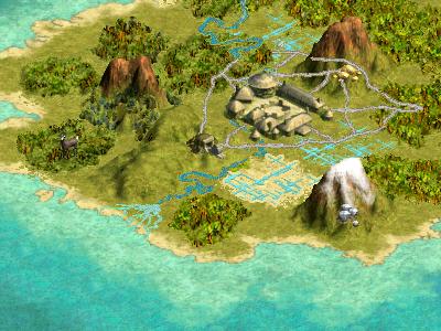
While automatic blending is nice it can't produce the same results as
if it was done by hand. Look at
http://www.civ3.de/www/content/misc/images/terrain-original.jpg. Look
how the hills around the mine are blended. Look at how the south coast
is blended. Especially at the coast you can't tell which tile is ocean
and which is land. This is a good thing IMHO.
This _is_ a good thing. But I am fairly positive it was not done by
drawing 2000 different tiles.
While I don't have any clue about how does the graphic engine of civ3
works the contents of this modpack
http://www.civfanatics.net/uploads2/cordy-terrain.zip reveals that
they also work with a system which is similar to our old one. Leaving
the extra height out of this the tiles of Mountains-snow.pcx are very
similar to our 16 tiles. In the x* files they blend three terrain
types. And yes these are a lot of tiles.

I think that the results show that they got this right. While I'm not
for coping their graphics/approach 1:1 I want to know why we don't do
the old way in the iso case. And the only answer I have is: because it
requires less graphics and so it was a solution which brought results
(i.e. a working iso-mode) faster.
The 'new' method is the civ2 method. I assume when the iso code was
written, they wanted to use the civ2 method since it was clearly
superior to the current method (which I will tentatively call the 'civ1'
method). From doc/HACKING:
[The current tile system should be converted to something like civ2's.
-They get away with drawing way less tiles, and it looks better. -PU]

That the civ3 method is better than either really doesn't affect this.
Note that the civ2 method does have multiple tiles for hills, mountains,
and forests. And that ocean tiles are drawn in 9 parts to accomodate
all the different coastlines.
What I would like to see in the long run is a separation from
civ1==non-iso and civ2==iso, and a modularization of the tileset
systems. Then we can think about introducing a 'civ3' method, if we can
figure out how their drawing was done.
But as I said, this is a long-term goal.

jason
- [Freeciv-Dev] (PR#2369) iso-view eye candy, Jason Short via RT, 2002/11/20
- [Freeciv-Dev] (PR#2369) iso-view eye candy, Jason Short via RT, 2002/11/20
- [Freeciv-Dev] Re: (PR#2369) iso-view eye candy, Raimar Falke, 2002/11/21
- [Freeciv-Dev] Re: (PR#2369) iso-view eye candy, Jason Dorje Short, 2002/11/21
- [Freeciv-Dev] Re: (PR#2369) iso-view eye candy, Raimar Falke, 2002/11/21
- [Freeciv-Dev] Re: (PR#2369) iso-view eye candy, Jason Dorje Short, 2002/11/21
- [Freeciv-Dev] Re: (PR#2369) iso-view eye candy, Raimar Falke, 2002/11/21
- [Freeciv-Dev] Re: (PR#2369) iso-view eye candy,
Jason Dorje Short <=
- [Freeciv-Dev] Re: (PR#2369) iso-view eye candy, Ben Mazur, 2002/11/22
- [Freeciv-Dev] Re: (PR#2369) iso-view eye candy, Jason Dorje Short, 2002/11/21
- [Freeciv-Dev] civ3 graphics system, Jason Dorje Short, 2002/11/22
- [Freeciv-Dev] Re: civ3 graphics system, Raimar Falke, 2002/11/22
- [Freeciv-Dev] Re: civ3 graphics system, Jason Dorje Short, 2002/11/22
- [Freeciv-Dev] Re: civ3 graphics system, baumans, 2002/11/22
- [Freeciv-Dev] Re: civ3 graphics system, Vasco Alexandre Da Silva Costa, 2002/11/22
- [Freeciv-Dev] Re: civ3 graphics system, Raimar Falke, 2002/11/22
- [Freeciv-Dev] Re: (PR#2369) iso-view eye candy, Anthony J. Stuckey, 2002/11/21
- [Freeciv-Dev] Re: (PR#2369) iso-view eye candy, Jason Dorje Short, 2002/11/21
|
|