[Freeciv-Dev] Re: (PR#3936) introducing native coordinates
|
Complete.Org:
Mailing Lists:
Archives:
freeciv-dev:
April 2003: [Freeciv-Dev] Re: (PR#3936) introducing native coordinates |
|
[Freeciv-Dev] Re: (PR#3936) introducing native coordinates[Date Prev][Date Next][Thread Prev][Thread Next][Date Index] [Thread Index]
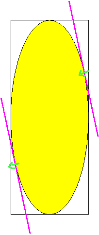
On Thu, Apr 24, 2003 at 02:01:17PM -0500, Jason Dorje Short wrote:
> >>>Question: is wrapping defined in compact form the same as
> >>>wrapping defined in iso-view form? IMHO yes but I'm not sure.
> >>
> >>Again you've lost me.  What is the iso-view form?  The form you get by
> >>looking at it in an isometric-view client?  This is the "natural" view
> >>of an iso map; the wrapping here is identical except that the scale is
> >>different.
> >
> >
> >Well the neighborhood in both forms is different. See
> >http://www.freeciv.org/~rfalke/grid_pics2/grid_iso1_wn.png and
> >http://www.freeciv.org/~rfalke/grid_pics2/grid_compact_wn.png. But it
> >looks that these difference don't matter for the wrapping case. In the
> >above case this means that if you start at the blue point and goes
> >west wards (NW, W and SW) you will reach the same tile no matter if
> >you go in the iso-view form or the compact form.
>
> But these are the "natural" and "native" form, and neither are used for
> finding adjacent tiles.  In particular the natural form isn't used at
> all, and the adjacent tiles can't be determined from the native form at
> all.  The DIR8 directions, therefore, are only of use (in the core code)
> for the "map" form.

Leaving out the masked form the compact form is used for storage and
enumeration. It is rather topology independent. Wrapping is a topology
operation. Here simple storage and topology is mixed. This makes it
hard to have something like the attached picture. In the attached
picture the yellow area are the real tiles. And the magenta lines
define a wrapping. So you can got the path denoted by the green
line. I'm not saying that such models should be supported now. It is
more that you should think about the the connection between the axes
in the compact form and the lines were wrapping takes place. IMHO
there is no strong connection between these two. We should make the
model as clear as possible with a low number of assumptions. And these
should be documented.

        Raimar

--
 email: rf13@xxxxxxxxxxxxxxxxx
 "That's fundamental game play!  My main enemy is *ALWAYS* fighting
  a 4-front war.  I make sure of it!"
    -- Tony Stuckey, freeciv-dev
|