[Freeciv-Dev] (PR#7295) scenario for spherical earth
|
Complete.Org:
Mailing Lists:
Archives:
freeciv-dev:
February 2004: [Freeciv-Dev] (PR#7295) scenario for spherical earth |
|
[Freeciv-Dev] (PR#7295) scenario for spherical earth[Date Prev][Date Next][Thread Prev][Thread Next][Date Index] [Thread Index]
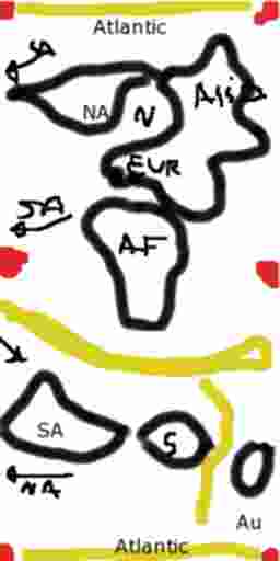
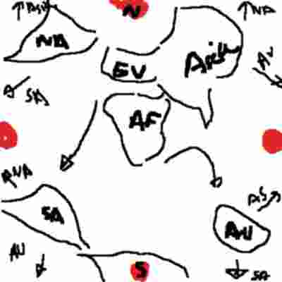
<URL: http://rt.freeciv.org/Ticket/Display.html?id=7295 >

The first scenario(draf)was used to test this topology whit a hacked
server v1.14. Many players like this.
The scenario is not perfect.But it is very nice sice this can played as
a fltt
map. this is good for a iso-view in a not TF_ISO map.
The bigger problem is  Pierce-Quincuntial projection is a equal-angles
projection. This make some continents too big. S. America and Africa. We
can correct it.
Oceans (pacific) can be smaller than real one.

We propose 2 concept map using reversed wrap more harded. this 2 maps
are very
nice with the TF_ISO iso-view-optimized maps.
1)Concept Map For Scenario in quincutial topology "WorldVQuinc"
================================================================
This is a Art-Map most than a Cartographic one. Continents need to be
near right placed.
Continent are 1:1 scaled but oceans can be littler .

my choice for this concept map is  to place all continent far of
singularities in vertical quincuntial topology.

The main axe is the long=30° Africa.

The vertical quincutial topology has a simplest Y wrap and reversed X
wraps. This make big overview maps. The best ratio is 1:2 (x:y) but we
can change it. The singularities to be avoided are in all corned and in
middle of L and R edges.


If atlantic is reduced we can go from NO to SA via the top edge.Best
wiht a big Altlanitic, this is more real.

Red:Singularities
Yellow:Big sea we can reduce (this reduce the X:Y ratio)

S. America and antartica can be plased a litled right.

2)Concept Map For Scenario in quincutial topology "WorldSqQuinc_Polar"
=====================================================================
in this one i plase poles in singularities this make a more conical view
of
Earth.
In this one North Pole is at N of Map and South pole at S of map!
|